The trailhead is located about a kilometer from the cattle guard where Chute Lake Road breaks over the hill onto the plateau.
(Km. 7.7) Look for a road headed east. It crosses the KVR within about 10 meters. Find safe parking off the road, and proceed
east a short distance before turning south (right) on a logging road cleared in the 1930’s. The trail is well marked.
What to look for
Log cabin remains
Moist plateau forest
Wildflowers
Deer (move quietly!)
Bridge and shelter
Views to west
While there appears from the maps ands name to be a single trail, there are in reality 3 trails strung together. Members
of the Chapman family who horse-logged in this area probably constructed the old logging road. They had a KVR siding that
they used to get the timber to a mill in Penticton. The dilapidated log cabins were part of their home and business. At least
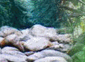
one child was born here. The area is damp forest with lush floor and small intermittent creeks. Look for ferns, devils claw,
cow parsnip and monkshood.
The logging road is about 2 km long, and may be exited to the KVR. There is a rough single-track leading on, linking up
to the third trail in 1.2 km. Following this track takes you over Natasha’s Bridge, past a shelter to a T-junction.
At the T, turn northwest (right) to rejoin the KVR, or left to continue.
The T-junction marks your entry onto a section of the tote road, which joined construction camps as a re-supply route.
For nearly 2 years about 2000 men toiled to create the cuts, fills, tunnels and track-bed of the railroad. You may trace their
footsteps courtesy of the Naramata Woodwackers, a group of volunteers who have rediscovered these historic routes and
keep them clear of deadfalls and safe for trekkers.
This section of the Tote Road is dedicated to original Woodwackers, Ted and Jean Smith. Local bikers refer to this
great ride as the Ted and Jeanie. Turn south and enjoy streams, wildflowers, mixed forest with fine views and easy-walking
trail. The track ends at the KVR at a peaceful picnic spot about 7 km from your trailhead.
You may choose to employ a vehicle shuttle if you plan to hike the whole trail, or to hike each section as a separate trail.
The linking 1.2 km of single-track is not really too suitable for bicycles. The Ted and Jeanie makes a great out-and-back
hike or bike!