Trailhead is along the KVR south from Arawana Road, above Lang’s Vinyard at steel gate. If you reach the toilet,
you have gone too far! Pass the gate and follow the clear trail to Scary Rock, a sharp climb. At its top, a trail exits
northeast, but you continue south. Soon you will cross an old graded roadbed and discover a small marsh area where giant blue
marsh grass predominates. Take the right or south fork in the trail. This well-defined track passes through Ponderosa parkland
without much variation in local relief. Note the gravel pit as you cross a short treeless plateau and enter a shallow basin.
What to look for
The view from Scary Rock
Ponderosa parkland
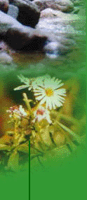
Riparian vegetation at Turnbull Creek
Balsam Arrowroot, Scarlet Gilia, Mariposa Lilly and other wildflowers in season
Giant blue marshgrass
Awesome views from the granite bluffs
Pine Drops and Pine Sap (Indian Pipe) Saprophytes!
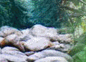
the Garden of Eden at Turnbull Creek
Climbing out of the basin, you cross a double track (connecting west with the KVR) and continue to the rim of Turnbull
Creek’s gully. A trail descends to the creek, but you want to stay on the rim trail where a brief climb puts you in
a riparian glade beside rushing Turnbull Creek. (A Garden of Eden) Following the track through trees brings you to the gas
pipeline R-O-W. The trail continues at the top of the bank on your left (north) as you stand looking upstream. (If you wish
to return to trailhead along the KVR, backtrack to the double-track mentioned earlier, and turn west and downhill to the railbed.)
At the top of the bank, disregard the cross-trail and proceed up the gentle incline that curves westward. Stay on this
track until it brings you to two rough up-hill sections that are close together. The second of these rises places you on a
plateau where you can see the pipe line R-O-W rising gently to the north. Follow! Just as you notice the trail grow steep,
careful study will reveal a level double-track heading across a glade to the northwest. Follow this track until you are on
the power line R-O-W.
The next 2 kilometers wind across granite fields following the service track. Soon grass vegetation will thicken as you
reach a low summit. Two single-track trails depart right, while your trail crosses a basin to arrive at the foot of a huge
climb. Relax… a single-track exits left through Bull Pass, an area that gave the bicycle trail builders trouble-on-4-legs!
At the base of the "Pass", take the right fork. (Left fork ends up the same place, but is for vigorous sorts on bicycles,
and adventurous hikers, being rougher and steeper.) Pass the next trail leaving left, and switch-back left before entering
the clearing. The next trail off to the right is scenic and shorter, arriving at Scary Rock. The longer route continues
down hill to intersect your up-trail among the giant blue bunch grass. Soon you will be at Scary Rock, then return
to trailhead.